One Year of Experience with Geotagging
Introduction
After using the Geotagging procedure described above for a year, I would like to share some experiences here.
Recording Track Points
As discussed above, it is necessary to consider how to record track points to achieve accurate photo positioning without overwhelming the storage space of the GPS device. With the aforementioned device (Garmin eTrex H), the storage space is limited to 10,000 track points.
It would be easiest, in theory, to record a point every second. This approach provides high positioning accuracy for most applications because there is always a point in the track data that is no more than half a second away from the recording time. If you are on foot, you can confidently record a point every 5 seconds. Walking at about 4 km/h, or approximately 1 m/sec, the position is accurate on average to 0.5 m. With a 5-second interval, it's still 2.5 m. However, since you stop (or at least should stop) to take photos, the accuracy is much higher. Most of the time, you will stand still for at least a few seconds. Therefore, the position is determined only by the accuracy of the GPS signal. However, this method requires a large amount of storage, as points are recorded even when not moving at all.
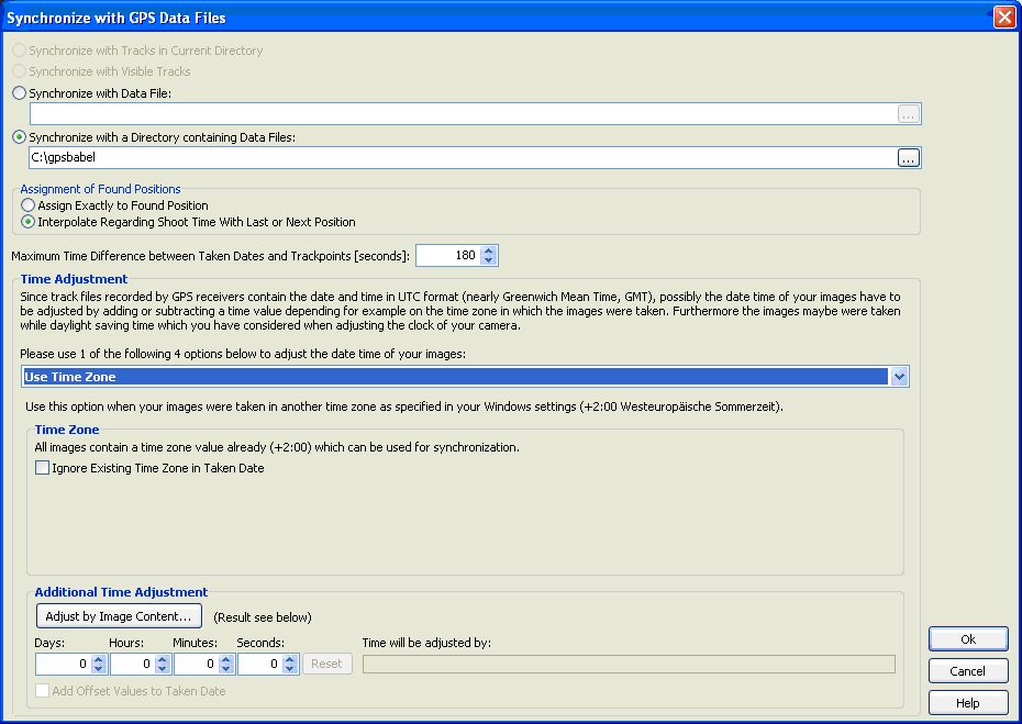
It would make sense to save a point only when leaving a location. However, in this case, the Geotagging program (in my case, Geosetter) may not find a point within the specified search interval (see figure below; Geosetter searches for a point within the specified 180 seconds from the recording time) if points were recorded, for example, when sitting somewhere without moving the GPS for an extended period but still occasionally taking a photo. In this case, you can either increase the interval time or manually find the point on the map. I have found that Geosetter at least finds a recording taken at that location. In such a case, I simply synchronize the position of that one recording to all others taken at the same location (see figure below: set current value for all selected images). Manual intervention is required in such cases.

The limitation of 10,000 points does not apply to actual GPS data loggers, of course. Today, most devices record over 100,000 points, and there are even devices that can store on an SD card (up to 25,000,000 points with a 2GB memory, Columbus V900). Assuming a 5-second interval, you can record continuously for about 14 hours with 10,000 track points, nearly 140 hours (6 days) with 100,000 track points, and 4 years with 25 million track points. Since you don't record continuously, you don't need to worry about the interval, at least with the last model mentioned. The Columbus V900 model does not offer the option to change the interval time; it is fixed at 1 second. However, with the large storage capacity, this is not a concern.
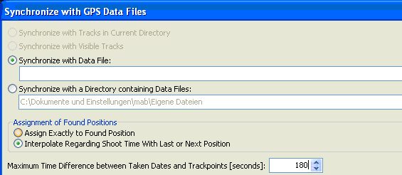
Geosetter also provides the option to calculate the geographic average between two track points for a given shooting time and adopt it as a coordinate set. This allows for more flexibility with less optimal interval times (see figure below: Interpolate Regarding Shoot Time With Last or Next Position).
Last year, I often used an automatic setup where the GPS applied a mix of distance and time interval, depending on how fast you are moving and how significant direction changes you make. This is practical, for example, when traveling by plane. In this case, you don't have to constantly change the settings for capturing track points when switching modes of transportation. The GPS dynamically adjusts the recording interval. It doesn't make sense to save a point every 10 meters when racing through the sky at 800 km/h. Garmin devices (at least the eTrex) allow you to set these automatic settings at various levels. At the highest resolution, the memory is sufficient for about a week if recording approximately 8 hours per day.
In summary, with today's GPS data loggers, it is easiest to work with a constant time interval and record more points, as practical limitations regarding storage are practically nonexistent. Even with a standard storage capacity of 100,000 points, you can easily endure a two-week vacation with a 5-second interval without having to read out the memory in between. Since you don't record day and night, a total track length of 140 hours (or 10 hours per day) is quite acceptable. If you are on the road for a longer period, you can also live with a 10-second interval.
Battery Life
One of the biggest problems with GPS devices is the limited lifespan or operating time achievable with a set of batteries. The device I use, the Garmin eTrex H, can operate for approximately 12 hours with rechargeable batteries (NiMH, 2x 1.5VDC, about 2Ah per battery). However, with older batteries, the device may run out of power after just a few hours. Therefore, it's essential to always carry spare batteries, and even if you're on the road for a few days, it's recommended to bring a battery charger. Here, I see a significant advantage in trackers with built-in batteries that can be easily charged via USB. The handling is more straightforward, as you can plug the device into the socket in the evening and start the next day with a fully charged battery. However, this setup proves to be a disadvantage when you don't have access to a power outlet, as you cannot replace the built-in battery. GPS loggers today have longer operating times compared to the eTrex. When purchasing a device, it's crucial to pay attention to how long a battery lasts and whether users have tested the manufacturer's specified time in practice. Some manufacturers tend to be generous in such specifications. For the mentioned Columbus V900 device, a battery life of 24 hours is indicated in pure log mode. This means you can go 2-3 days without recharging the battery.
Tracking Accuracy
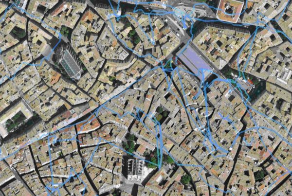
The sensitivity of GPS receivers has continually improved in recent years. Even the eTrex H I use shows significantly better reception performance compared to its predecessors. The commonly used MTK chipset today is expected to offer a slight improvement. However, especially in cities with narrow streets (see figure below, in the alleys of Montpellier), you cannot rely on the device's reception accuracy. On one hand, you carry the device somewhere in a bag, where the satellites are not only shaded by tall buildings but also by your own body. This deteriorates reception quality or positioning accuracy, and in narrow streets, you may experience either poor geodata or a loss of GPS reception. In theory, you could attach the GPS to a backpack higher up, positively influencing reception properties. However, I prefer a discreet shoulder bag for my photo equipment. Perhaps smaller devices like a dedicated GPS data logger can be somehow improved by attaching them to the shoulder strap. Newer devices may show improved performance even when carried in a bag. In any case, I found reception performance to be a limiting factor in cities during various trips. In rural areas, reception quality is excellent, and even in the car, you can easily use the device without finding an optimal position for the GPS receiver. Despite having a front windshield heater in my car, the device's reception performance is outstanding.
You can also use the GPS in an airplane. It is advisable to check beforehand whether the operation of a
GPS
device is allowed by the respective airline. It is recommended to determine the position with the device
shortly before boarding. This saves the latest satellite data (Almanac) in the device, and the GPS does
not
have to search for satellites for a long time when turned back on, allowing for an accelerated warm
start.
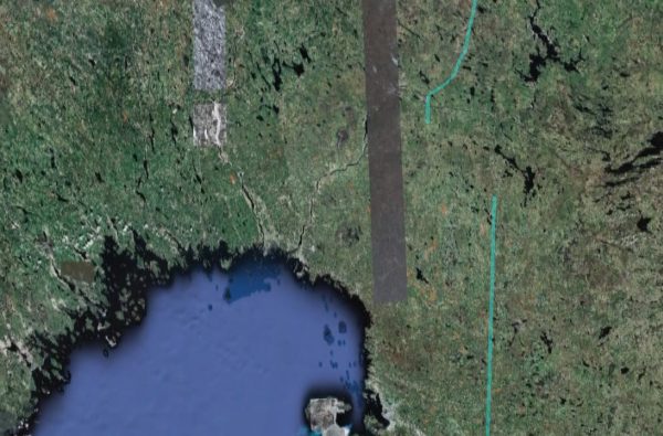
In my device, it often happens that due to one-sided reception (sitting by a window), the position is
only
inaccurately determined. Apparently, the device projects the position onto the ground, thinking that you
are
flying a few kilometers away from the real position, so to speak, on the Earth's surface (see figure
below,
flight over Lapland, the offset is approximately 40 km!).
This error is hardly noticeable during the flight, but during landing, the altitude above sea level is
completely miscalculated, and the error becomes noticeable. Sometimes, even the GPS realizes that it has
miscalculated and takes quite a while to correct itself. A brief on-off cycle usually corrects the
misbehavior. If you frequently check the flight altitude (typically around 10,000 meters) during the
flight,
this error should become apparent. I have also found that this behavior occurs less frequently if, as
mentioned above, the device is briefly updated with the latest Almanac before boarding. Of course, this
only
works at the window. I usually place the GPS on the armrest below the window and have achieved good
results.
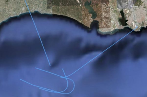
Only during a curved flight, reception failures can occur (see figure below, queues in the approach to
Istanbul, the reception cuts out repeatedly), of course, only when sitting on the right during a right
turn,
and vice versa, as the aircraft tilts inward, reducing the visible sky. I am curious to see how newer
chipsets behave in such situations.
Geodata as Metadata
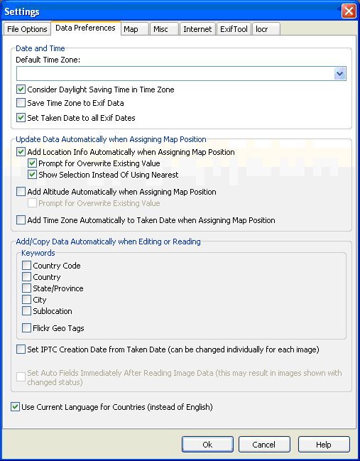
Some programs, including Geosetter, offer the option to find not only the pure coordinates but also the corresponding location with state and country from an internet database. These data are then written into the respective metadata fields of the image file. Alternatively, you can choose to automatically enter all or parts of this data as keywords (see image below: Add/Copy data automatically when Editing or Reading).
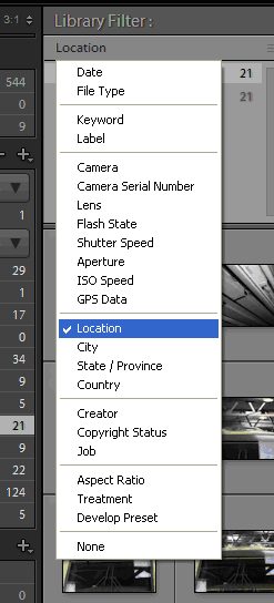
In Lightroom, keywords are also managed. If you instruct Geosetter to record all geographical data as keywords, you quickly end up with too many different keywords. This affects clarity. Additionally, Lightroom can search for geographical data (i.e., city/state/country) in the corresponding metadata fields for Location Information (see image below). Therefore, it is not necessary to duplicate this geodata in the image file's metadata. I would recommend deactivating these options.
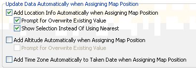
Another function that may seem useful is overriding the altitude above sea level (see image above). Because the accuracy of altitude measurement of a GPS device is always lower than the accuracy of coordinates, this function can be useful. Additionally, the altitude information may not be read from the tracking data because either the field was not written or not correctly written by the GPS receiver. However, you can check this in the GPX data; the <ele> field must be filled accordingly:
<trkpt lat="48.148612976" lon="16.277832985">
<ele>296.704102</ele>
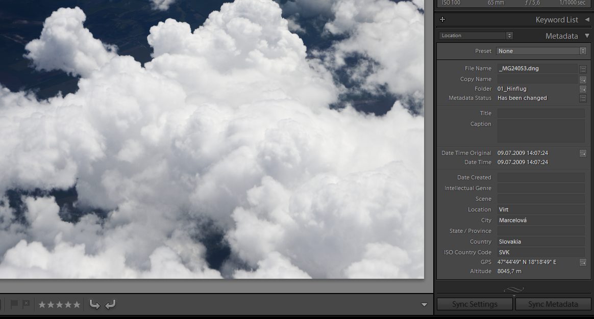
As long as you are on the Earth's surface, Geosetter correctly replaces or supplements altitude information. However, if you are in an airplane (see image below, at 8000m altitude) or on a tall tower, the altitude information read from the map makes little sense. So, caution is advised. Therefore, I have also deactivated this function, as I prefer to have no or inaccurate altitude information rather than incorrect information.
These error phenomena do not occur with the Columbus V900. The receiver also seems to have higher sensitivity than the eTrex H. For example, I could not receive GPS signals with the eTrex H inside a high-wing aircraft, but the Columbus worked flawlessly. In general, the Columbus has become a very versatile device due to its small size, relatively good battery life, and excellent reception quality. Additionally, it records a point every second, allowing precise synchronization of track data with photos. Furthermore, the storage is extremely large, so you practically never have a problem with too much data. And finally, the device can be easily charged via USB. The only drawback: To download, you need to remove the very small micro-CF card from the device; the USB connector is only for charging.